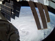
Die Informationen zu den folgenden Fotos und dem Video sind eine exakte Kopie der NASA-Beschreibung in englischer Sprache. Astronaut Douglas Wheelock aboard the International Space Station (ISS) caught this image of the eye of the storm as the ISS flew over Hurricane Earl just to the east on Sept. 3. Wheelock noted that it looks like magnificent chaos from up there on the Space Station and called it incredibly breathtaking.
Credit: NASA, Douglas Wheelock
Cameras mounted on the International Space Station captured new views of Hurricane Earl late in the afternoon of Sept. 2 from an altitude of 218 statute miles as the storm churned due east of South Carolina heading north on a track that would skirt the eastern seaboard of the United States. Earl was packing winds of about 115 miles an hour at the time the video was acquired. This image from the GOES-13 satellite at 7:32 a.m. EDT on September 3 shows a huge Hurricane Earl northeast of North Carolina with cloud cover stretching over the northeastern U.S. A disorganized Fiona is located in the bottom right side of this image
Credit: NOAA/NASA GOES Project  This photo of Hurricane Earl's eye was taken from the HDVis camera on the underside of the Global Hawk aircraft during the morning of Thursday, Sept. 2 at 13:05 UTC (9:05 a.m. EDT). The Global Hawk captured this photo from an altitude of 60,000 ft. (about 11.4 miles). The Global Hawk is one of three aircraft involved in the Genesis and Rapid Intensification Processes (GRIP) experiment. GRIP a NASA Earth science field experiment from August 15-September 30, 2010 to better understand how tropical storms form and develop into major hurricanes. Credit: NASA/NOAA
Die aktuellsten Erdbeben weltweit (2,5+)
Archives
DUJUAN zieht als Taifun nach China.
MARTY: Sturmwarnung S-Mexiko (Atlantik). Chiapas, Michoacán und Guerrero sollten mit Sturmbedingungen rechnen, Landfall unwahrscheinlich.
JOAQUIN wird Wetter an US-East-Coast beeinflussen.
Hurrikan EARL: NASA-HQ-Foto und Video von der ISS + Foto im Auge (Eye) vom Global Hawk Aircraft
Samstag, 4. September 2010
um 05:38
Labels: 2010, Atlantik, Earl, Hurrikan Satellitenbilder, Hurrikanfotos, Hurrikansaison 2010, NASA, USA, Video
Abonnieren
Kommentare zum Post (Atom)


0 Kommentare:
Kommentar veröffentlichen